
Basic Navigation Skills
Learning these basic wilderness navigation skills is an essential part of outdoor living.
“Hm…Been fearsome confused for a month or two, but I ain’t never been lost.” This memorable quote comes from the movie The Mountain Men. Although humorous, it has a bit of a lesson in it. That is, if you have the necessary skills and gear, being lost might not bother you too badly. After all, if you can learn to live in the outdoors, you don’t have to know exactly where you are every single moment. You have the gear and skills to live wherever you happen to be. Years ago, my dad, cousin, and I took a pack trip into a Colorado wilderness. Early on, we took a wrong turn and spent the next three days wandering around the mountains. It wasn’t a big deal, though. We had everything we needed to enjoy the next few days, and we eventually found our way back. That being said, it’s not ideal to be “fearsome confused.” To avoid that predicament, you can develop some basic wilderness navigation skills.
I was lucky to grow up with easy access to the wilderness. We grew up on a ranch that bordered National Forest that bordered wilderness. Out my back door, we had access to hundreds of thousands of acres. At a certain point, this type of upbringing helps when it comes to navigation. My friends and I ventured out a little bit at a time, and we learned to find our way back. Over time, our excursions got longer and longer and we continued to develop an ability to find our way around. People who spend lots of time outdoors can develop a natural sense of direction that they carry with them for life.
Fortunately, you don’t have to grow up like Huck Finn to navigate. Mastering these basic wilderness navigation skills can help anyone travel more confidently in the outdoors.
Basic Wilderness Navigation Skills
Map Reading
One of the first things you should do to develop your navigation skills is to practice map-reading skills. As a Geography teacher, this is one thing that all my students get familiar with. Admittedly, I’m a map nerd, so I’ve been fiddling around with maps for as long as I can remember. For those of you who need a little refresher in map reading, here are some basic things to know.
Title
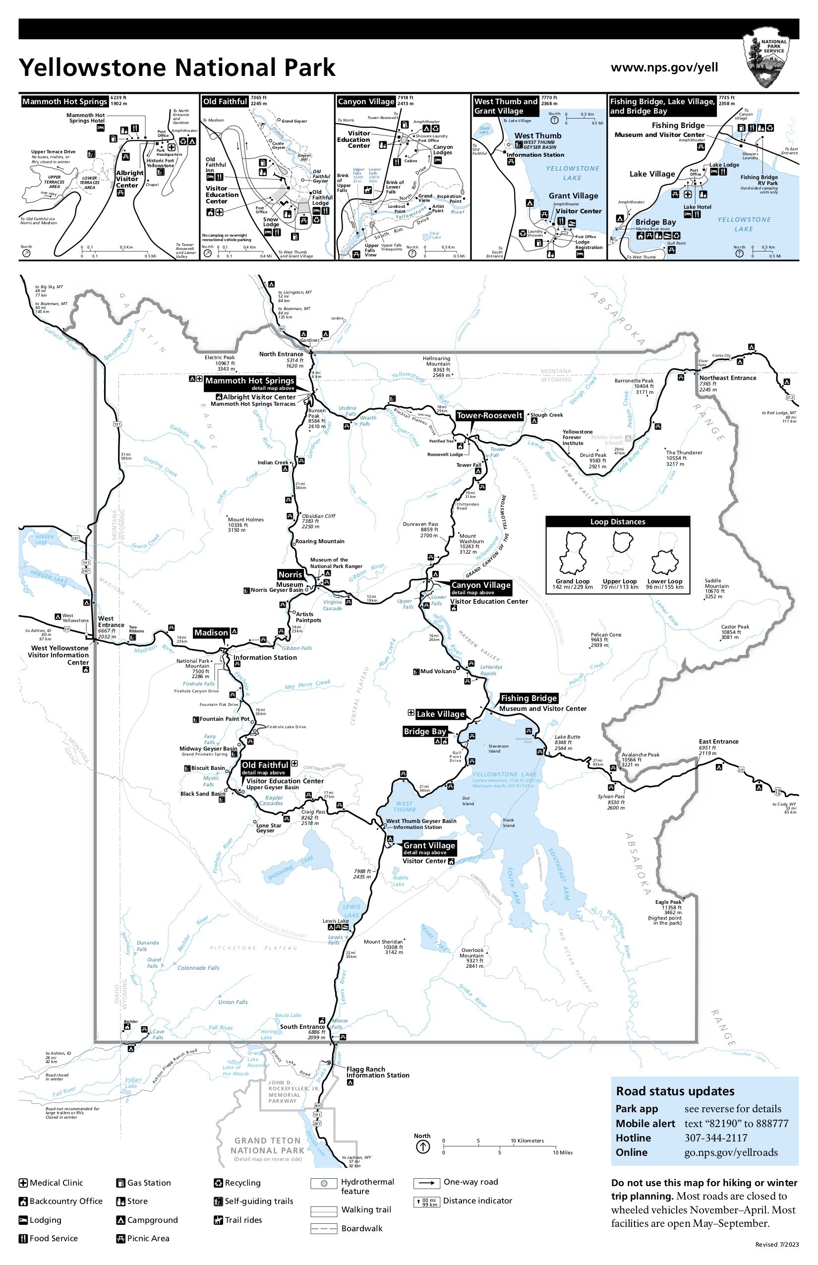
The title of the map tells you what the map is about. This might sound like something obvious, but it’s worth noting. For example, the map at the right is of Yellowstone National Park.
Scale
The scale is the part of the map that relates to distance. Most quality maps have a scale. Scales show how far a distance on a map relates to distance in real life. For example, the map scale on the map shows how far on this map equals 10 miles in real life.
Compass
Maps should also have a compass. The compass shows directions on the map. When you are holding the map, north on the map should be north in the world. Basically, you should be looking north and the compass on the map should be pointed north as well. You can see the N on the this map.
Key
Finally, the key tells you what colors, symbols, and types of lines mean. This can be helpful for lots of reasons. For example, looking at the map, you can see all the symbols at the bottom.
The key can also help you understand where trails are, and what type of trail you can expect. Is it a road, ATV trail, or just a hiking trail? Look to the key to find out.
Map Reading Tips
After learning the parts of a map, you next need to learn how to actually read the map. How you read the map depends a lot on what type of map you have. A generic Forest Service map is quite a lot different from a highly detailed topographic map. However, there are a few things to keep in mind.
Number one, as already mentioned, make sure the map is held in relation to the world around you. This can be really helpful in forming an accurate mental map. Secondly, use the map to locate important features around you. They might be roads, trails, or physical features. Knowing where features are located in relationship to others can be helpful as you create your mental map of the area. Finally, be sure to check your map often, especially if you are in a new area.
TOPOGRAPHIC LINES
One of the final skills in map reading is learning to understand topographic lines. Many good maps of wilderness areas have topographic lines. This is most true when the map is depicting areas that have significant elevation changes. That’s because topographic lines are lines that show elevation changes. These lines may appear to run in erratic ways, but are instead, highly precise.
Each line denotes a specific elevation above sea level. In most all cases, the map marks specific demarcations of elevation. For example, the map may identify lines every 500 feet above sea level. You’ll see lines marked with numbers like 1,000, 1,500, 2,000, etc. That means, wherever that line is, it is that high above sea level. However, between those marked lines, there are usually other lines that are not marked. Going back to our example of lines marked every 500 feet, you may have one unmarked line in between. As you may already have guessed, that unmarked lines would indicate 250-foot changes in elevation. You just have to be able to do the math.
Understanding topographic lines is very helpful when you are in an area you are unfamiliar with. We often use these maps when we go camping in the Rockies. They help us gain a detailed understanding of where we are, what to expect ahead of us, and what is around us. For example, imagine we are planning the ride for the day and we see the trail ahead has many lines stacked closely upon one another. That indicates the elevation changes very rapidly at that location. Depending on which way we are traveling, that may mean a steep uphill or downhill climb can be expected. If we ever get a bit turned around as to where we are, we can take a minute to look at the landforms surrounding us. Big mountains, deep valleys, or large meadows can usually be located fairly easily on a topographic map. Once you find them on the map, you can usually find your location fairly easily.
Compass Skills
You probably aren’t surprised to read that compass skills are included with these basic wilderness navigation skills. A compass is a simple tool that is around 1,800 years old. The fact that the basic tool still finds its way into most wilderness kits is a testament to its usefulness. When combined with a map, the compass can help you keep the map orientated to the world around you. Without a map, the compass can still be a handy tool. For example, when I lived in Florida, I used to go exploring the Everglades. Coming from the mountain states, the Everglades were more than a little different. One challenge that I struggled with was navigating without landmarks. Like the prairie I travel these days, this means you have to rely on other methods of getting around. In this case, a compass was a good tool to get around. Although it wouldn’t get me to an exact point, it could help me determine my general direction of travel. So, if I left the pickup traveling north and west, I knew I could get back to where I started if I traveled south, and then east. In areas like that, checking the compass often keeps you from walking in circles.
Modern Tools
Discussion of basic wilderness navigation skills should include at least a line or two on modern technology. The reality is that modern GPS and satellite technology make navigation easy. Push a few buttons, learn the software, and most anyone can get around. It really is that easy.
As good as modern technology is, it does come with a caution. That is, like all other technology, when it breaks or runs out of batteries, what are you going to fall back on? This might not be a factor if you are going out for two days. However, like everything else, the longer you plan on staying out, the bigger the challenge to keep it functional. Will you bring a solar charger or extra batteries? Does it need a rain-proof container? None of these considerations is a deal-breaker, but it can add to the headaches. If nothing else, developing the hard skills of map reading and compass use can serve as a foundation to fall back on if your technology stops working. Real-world skills still have a place in our high-tech world. Keeping it simple really does have its advantages.
Once you get competent with a compass and maps, you really can go about anywhere. Like all skills, these basic wilderness navigation skills do take time, attention, and energy to learn. However, they don’t need a battery or monthly subscription plan to stay operational. Learn to use them, and you can avoid getting “fearsome confused for a few months.”